
Sometimes it’s worth looking back at the renderings made by architects and to compare these with the finished product. In this case, we’ve done comparisons with the work shown during the controversial rezoning of 228-246 East Broadway and 180 Kingsway (now known as ‘The Independent’, also referred to as ‘the Rize’ during the rezoning). Here we’ve posted several comparisons of renderings shown during the rezoning stage of this project along with corresponding photos taken in the field. Clearly, the renderings misrepresented the height of the building as well as the location. Compare for yourself. The shadow studies were also incorrect (see comparisons further below).
Acton Ostry Architects is also the firm responsible for the drawings submitted for the 21-storey tower rezoning at 1551-1581 West 7th Ave (online Q&A 13-26 March, details here).
The Broadway Plan clearly states that no new shadows on public parks are permitted between 10am and 4pm on the equinox. We’ve included a number of renderings that show that new shadows will indeed be cast on 6th and Fir Park (future Burrard Slopes Park) during this time (or more precisely, from 10am to about 11:38am on the spring equinox). City staff posted shadow analysis from the architect, and subsequently claim in a Q&A answer: “shadows from the building only skirt the southern edges of the park, between 10am-11:30am.” [Update: see our new post here for additional shadow study comparisons]
Fake shadow studies in this case are being used to circumvent the meager solar access protections for parks in the Broadway Plan. City staff are more than willing to post materials straight from the architect, without checking the materials themselves even after someone asks a question in the Q&A session. It also appears that the ‘Q&A’ session has now effectively been unofficially ended, as we’ve heard from residents that City staff are not responding to follow-up questions during their ‘consultation’ (which is a process City staff creating using their own rules, and now staff are not answering questions within 2 business days in their limited two week window for a Q&A session). As the City’s once-public processes continue to recede behind a virtual wall and municipal officials and staff increasingly avoid direct public contact, the undermining even of online interactions is not acceptable.

During the rezoning of ‘the Independent’, City staff had internally made comparisons with the architect’s renderings and with their own internal 3D computer model. This information was never released to the public prior to the end of the Public Hearing, and was obtained thanks only to an FOI request.
However, the image below shows that staff have the capacity to verify renderings for accuracy. It also demonstrates that City staff know that Acton Ostry Architects have a track record of submitting inaccurate renderings.

The following comparisons were made using the architect’s renderings and photos taken in the field:


Anyone can grab a camera, go into the field, and take photos for themselves to compare the architect’s renderings with the height and massing of what was constructed in the end. For the rezoning (of 246-256 E Broadway and 180 Kingsway), there will be some minor differences in details from the DP phase and adjustments to height and stepping of buildings along Broadway; however, the main tower height at 180 Kingsway will remain the same.
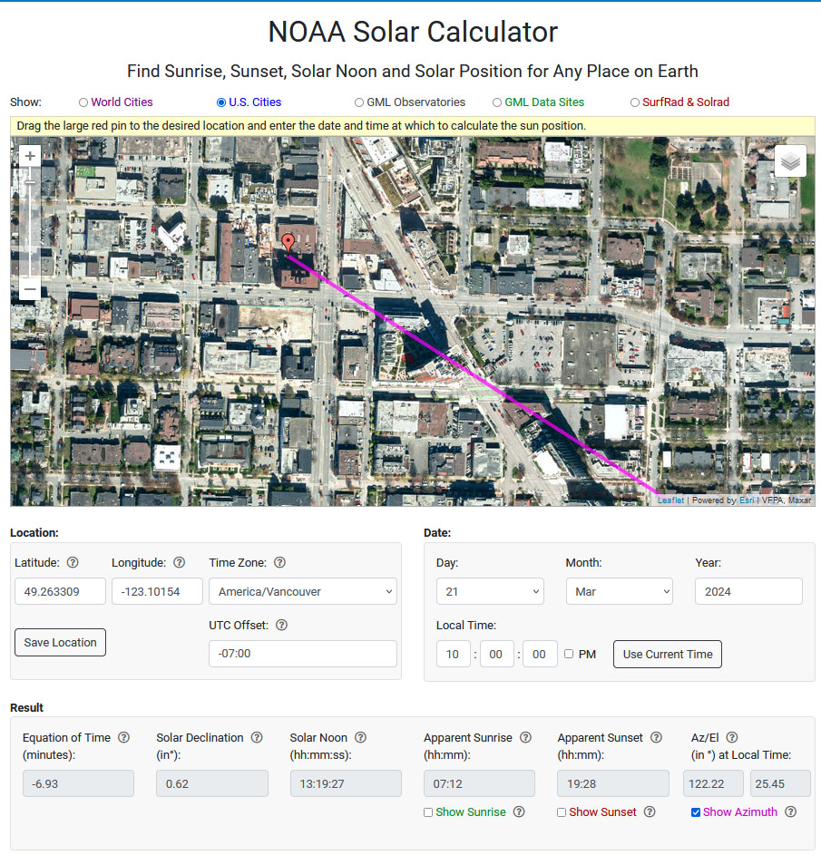
Shadow studies might be a little bit more work to check without a 3D rendering package; however, the general direction of the shadows can be very quickly verified using free online tools such as the NOAA Solar calculator. The original shadow study included with the rezoning application for 228-246 E Broadway and 180 Kingsway is reproduced below:


For reference, the original street level views study shown during the rezoning stage is reproduced below (see this link for the full archive of the materials shown for 228-246 East Broadway & 180 Kingsway, which includes the shadow study archive):


Resources
1551-1581 West 7th Ave rezoning (online Q&A 13-26 March). 21-storey tower would shade Burrard Slopes Park. Application (on ShapeYourCity) clearly violates Broadway Plan solar access policy, CityHallWatch, March 13, 2024
2328 Galt Street: Compare photos with renderings and model, CityHallWatch, December 28, 2020
Burrard Gateway (One Burrard Place) rendering vs reality. A look at the Skyline Study. CityHallWatch, April 7, 2021
Fantasy renderings vs real world views for rezonings & developments: A case study using the Semlin & 12th Ave rezoning (CityHallWatch, June 8, 2020)
Burrard Gateway (One Burrard Place) rendering vs reality. CityHallWatch, December 4, 2020
Lack of rules for architectural renderings results in the Wild Wild West for developers (CityHallWatch, June 2, 2020, with links to previous posts on this topic)
CALP-Visioning-Guidance-Manual-V1-1 (UBC)
For the record, here’s the screenshot from the ShapeYourCity.ca page for 1551-1557 West 7th Avenue (on Monday, March 25, 10:15am):


Why don’t you take this analysis to the AIBC and make an unethical professional practice complaint. And also ask the AIBC to issue a directive to all members requiring them to accurately depict their renderings and shadow diagrams and other approval documentation. Ask them to back that up with stiff fines and license suspension for repeated offenses.
Get legal assistance.
On Mon, Mar 25, 2024, 10:54 a.m. CityHallWatch: Tools to engage
I agree with Bill. We can’t let this continue. Every single architect, no matter the firm, is doing these incorrectly. I applaud City Hall Watch for providing this free public service and shedding light (pun intended!) on the truth.
Great idea, but it seems only AIBC members can initiate this kind of review. And the AIBC has already displayed very recently how they deal with issues of professionalism among their members, by accepting a bogus complaint that silenced another member during the very crucial and time-sensitive public debate about the Broadway Plan. In the end the case was dismissed as groundless. With no remedies against the vexatious/anonymous complainant.
Pingback: Two towers proposed at 2950 Prince Edward St, Kingsway & East 13th are proposed (32 and 25 storeys) near Mount St. Joseph Hospital. Public Q&A ends April 9. School shading & tower height violate Broadway Plan. Applicant Quadreal = B.C. pension