Below is a series of the plans we have compiled and analyzed to show the evolution of the Grandview-Woodland plan, one of the hottest (most controversial) planning areas in Vancouver at the moment.
What happens there this year will certainly determine the fate of this unique and treasured neighbourhood. But this story also exposes enormous, citywide implications about the systems and culture hidden behind the walls of City Hall, far beyond the scrutiny and influence of residents and taxpayers. Something must change.
Under public pressure, the City of Vancouver recently released a series of draft plans that were made prior to the contentious June 2013 “Emerging Directions” land use plan for the Grandview-Woodland neighbourhood. A total of 71 drawings dating from September 2012 to June 2013 are now available for download from the City’s website (in a huge, single, compressed 1.5 GB zip file, available here).
(Update: We have confirmed that while all of these machinations and power plays were going on at City Hall from February to June 2013, the topic of the land use maps never came up at any public meetings. Not much consultation occurred prior to the release of the “Emerging Directions” land use plan.)
The drawings graphically confirm reports of political interference (reports leaked from a former planner and a current city employee). Further details on this are available in a previous post: Inside story of a botched community plan process: How top-down interference led to 20 towers proposed for Grandview-Woodland (CityHallWatch, Nov 13, 2014).

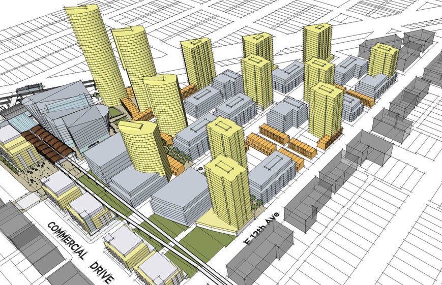
Land use plan March 22, 2013
The evolution of the land use plan also shows a struggle between planners working on the project — who were trying to make a plan that was well-integrated with the community — and Vancouver Manager of Planning and Development Brian Jackson’s (and/or his masters’) vision of towers for the community. (Also at stake could be about $10 billion dollars in tower construction, but that’s another story.)
The draft plan from February 2013 was successively “refined” into a comprehensive land use plan during March that year. After the changes, a drawing dated March 22, 2013 (click on inset to enlarge) still shows that the “heritage core” of Grandview-Woodland would remain intact. Two tower sites on the Safeway property near Broadway and Commercial were labelled as 28 and 22 storeys (originally identified as 18+ storeys in February). There was also an 11-storey high-rise on the southeast corner of Commercial and Broadway. Higher buildings were also proposed along a section of East Hastings, with buildings up to 10-storeys high west of Commercial, and up to 12-storeys high on the block between McLean Drive and Clark Drive. Otherwise, additional density was sought predominantly along arterial streets around the edges of the neighbourhood in denser, low-rise forms of housing, with Commercial Drive retaining its existing character (on the stretch from 7th Avenue to Venables).
The biggest changes between February and March 2013 were around Broadway and Commercial; a detail of the drawing is reproduced below:
This March plan was likely the one shown to Jackson. The inside source at City Hall reportedly said:
The proposal was showed to Brian Jackson, the city’s Manager of Planning and Development. “He went ballistic.” Jackson “lambasted” the planners for not including any tall towers. “It was very ugly.” Then he ordered them to go back to the drawing board and produce a plan that packed in as many towers as was possible.
The planners complied with Jackson’s orders and subsequently produced land use plans with more than 20 towers. Below are two enlarged sections of a tower plan (May 21, 2013). The first image is of an area east of Commercial and south of Broadway (and the Grandview “Cut” / rail corridor). (The orange objects are towers.)

Towers were also proposed north of Broadway, between Clark and Commercial:

A shadow diagram (below) for a scheme with 21 towers is dated 2013/05/17, and this map also identifies the tower sites:

The updated plan was again reviewed, as previously documented:
“Under protest” the planners complied, and brought back a plan containing 20 tall towers. Jackson showed this plan to Mayor Robertson and City Manager Ballem. They were pleased with the concept, but Robertson expressed some concern about “pushback” from the community heading into an election year. He suggested that the number of towers be “dialed down.”
Jackson then directed the planners to reduce the number of towers by half. Again they complied, but once again “under protest”. This satisfied Jackson (and presumably Robertson and Ballem). The plan was released in a document titled Emerging Directions.
Below are a few examples of the plans containing around 10 towers as requested by Mayor Robertson (from late May and June 2013): Continue reading →